Zion Free Gospel Chapel

Still looking at googlemaps to see what is there now and there seems to be a big tree  and an Elizabeth Street.
MaryA
Our Facebook Page
Names - Lunt, Hall, Kent, Ayre, Forshaw, Parle, Lawrenson, Longford, Ennis, Bayley, Russell, Longworth, Baile
Any census info in this post is Crown Copyright, from National Archives
Our Facebook Page
Names - Lunt, Hall, Kent, Ayre, Forshaw, Parle, Lawrenson, Longford, Ennis, Bayley, Russell, Longworth, Baile
Any census info in this post is Crown Copyright, from National Archives

I believe that space to be occupied by the landscaping adjacent to the Sherrington Building, part of Liverpool Uni..
Sherrington Building:
The Sherrington Building houses two lecture theatres with seating capacities of 586 and 238. Audio-visual aids are incorporated into a state-of-the-art system within each lecture theatre. A café is situated on the ground floor of the building.
DS
Sherrington Building:
The Sherrington Building houses two lecture theatres with seating capacities of 586 and 238. Audio-visual aids are incorporated into a state-of-the-art system within each lecture theatre. A café is situated on the ground floor of the building.
DS
DS
Member # 7743
RIP 20 April 2015
Emery, McAnaspie/McAnaspri etc, Fry, McGibbon/McKibbion etc, Burbage, Butler, Brady, Foulkes, Sarsfield, Moon [Bristol & Cornwall].
Census information is Crown Copyright http://www.nationalarchives.gov.uk/
Member # 7743
RIP 20 April 2015
Emery, McAnaspie/McAnaspri etc, Fry, McGibbon/McKibbion etc, Burbage, Butler, Brady, Foulkes, Sarsfield, Moon [Bristol & Cornwall].
Census information is Crown Copyright http://www.nationalarchives.gov.uk/

This LHP map shows "Pembroke Baptist Chapel" near to that location so I'm going to stick with my Marmaduke Street chapel theory  .
.
http://www.liverpoolhistoryprojects.co. ... z/np79.htm
Blue
http://www.liverpoolhistoryprojects.co. ... z/np79.htm
Blue
Member No. 8038
NIL SATIS NISI OPTIMUM
NIL SATIS NISI OPTIMUM
Hi Blue,
Now I have seen that map it is hardly likely there were 2 chapels across the road from one another, so I am going with the location on the opposite corner on the other side of Crown Street, between West Derby Street and Crown Street.
DS
Now I have seen that map it is hardly likely there were 2 chapels across the road from one another, so I am going with the location on the opposite corner on the other side of Crown Street, between West Derby Street and Crown Street.
DS
DS
Member # 7743
RIP 20 April 2015
Emery, McAnaspie/McAnaspri etc, Fry, McGibbon/McKibbion etc, Burbage, Butler, Brady, Foulkes, Sarsfield, Moon [Bristol & Cornwall].
Census information is Crown Copyright http://www.nationalarchives.gov.uk/
Member # 7743
RIP 20 April 2015
Emery, McAnaspie/McAnaspri etc, Fry, McGibbon/McKibbion etc, Burbage, Butler, Brady, Foulkes, Sarsfield, Moon [Bristol & Cornwall].
Census information is Crown Copyright http://www.nationalarchives.gov.uk/
But would Zion Free Gospel Methodists attend a Congregational Chapel? I was married in a Salem Baptist Chapel and we had quite a job persuading non-Baptist [but C of E of sorts never-the-less] guests to attend the ceremony, and that was 3/4s of a century later.Blue70 wrote:
Pembroke Baptist Chapel - No!
Marmaduke Street Edge Hill - Yes!
Blue
DS
DS
Member # 7743
RIP 20 April 2015
Emery, McAnaspie/McAnaspri etc, Fry, McGibbon/McKibbion etc, Burbage, Butler, Brady, Foulkes, Sarsfield, Moon [Bristol & Cornwall].
Census information is Crown Copyright http://www.nationalarchives.gov.uk/
Member # 7743
RIP 20 April 2015
Emery, McAnaspie/McAnaspri etc, Fry, McGibbon/McKibbion etc, Burbage, Butler, Brady, Foulkes, Sarsfield, Moon [Bristol & Cornwall].
Census information is Crown Copyright http://www.nationalarchives.gov.uk/
Hi DS
You inspired me to do another search and here's another twist to this one. There was a church called United Free Gospel Church on Elizabeth Street not far from your Pembroke/Crown Street location. The map for this location appears to be pointing at the same place as your map:-
http://www.genuki.org.uk/cgi-bin/church ... AN,ID=2560
Both maps appear to be pointing at the wrong place. If you look at the LHP map there are two little chapels at the southern end of Elizabeth Street one of them must be the United Free Gospel Church. Could this be the one we've been searching for?
http://www.liverpoolhistoryprojects.co. ... z/np79.htm
Blue
Member No. 8038
NIL SATIS NISI OPTIMUM
NIL SATIS NISI OPTIMUM
Hi Blue,
The Genuki map shows the United Free Gospel Church as #1 Elizabeth Street, which would put it under the Sherrington Building. That's within yards of the map I posted.
The other map with the two chapels at the other end of the street look quite redeveloped on Google E.
Talk about chapels, chapels everywhere......
What is the theological difference between the United Free Gospel Church and the Zion Free Gospel Chapel? Anyone an expert on them old-time-religions...?
DS
PS: Noticed you have an interest in the McGuinness name. Not a Thomas McGuinness born about 1848 in Swords, County Dublin, Ireland by any chance?
DS
Member # 7743
RIP 20 April 2015
Emery, McAnaspie/McAnaspri etc, Fry, McGibbon/McKibbion etc, Burbage, Butler, Brady, Foulkes, Sarsfield, Moon [Bristol & Cornwall].
Census information is Crown Copyright http://www.nationalarchives.gov.uk/
Member # 7743
RIP 20 April 2015
Emery, McAnaspie/McAnaspri etc, Fry, McGibbon/McKibbion etc, Burbage, Butler, Brady, Foulkes, Sarsfield, Moon [Bristol & Cornwall].
Census information is Crown Copyright http://www.nationalarchives.gov.uk/
Hi DS
My McGuinness people were from County Cavan. My Great, Great, Great, Great Grandmother was born Bridget McGuinness. She married Michael Brady and the family came over to Liverpool at the time of the famine. First record of them in Liverpool is 1848. They had a relation called Michael McGuinness who lived in Raymond Street. The family lived off Scottie Road, Vauxhall Road & Great Howard Street.
Blue
Member No. 8038
NIL SATIS NISI OPTIMUM
NIL SATIS NISI OPTIMUM
Thanks for that Blue. The McGuinness I am looking at was born in Swords, north County Dublin, about 1848. It was a passing thought.Blue70 wrote:Hi DS
My McGuinness people were from County Cavan. My Great, Great, Great, Great Grandmother was born Bridget McGuinness. She married Michael Brady and the family came over to Liverpool at the time of the famine. First record of them in Liverpool is 1848. They had a relation called Michael McGuinness who lived in Raymond Street. The family lived off Scottie Road, Vauxhall Road & Great Howard Street.
Blue
DS
DS
Member # 7743
RIP 20 April 2015
Emery, McAnaspie/McAnaspri etc, Fry, McGibbon/McKibbion etc, Burbage, Butler, Brady, Foulkes, Sarsfield, Moon [Bristol & Cornwall].
Census information is Crown Copyright http://www.nationalarchives.gov.uk/
Member # 7743
RIP 20 April 2015
Emery, McAnaspie/McAnaspri etc, Fry, McGibbon/McKibbion etc, Burbage, Butler, Brady, Foulkes, Sarsfield, Moon [Bristol & Cornwall].
Census information is Crown Copyright http://www.nationalarchives.gov.uk/
-
marky
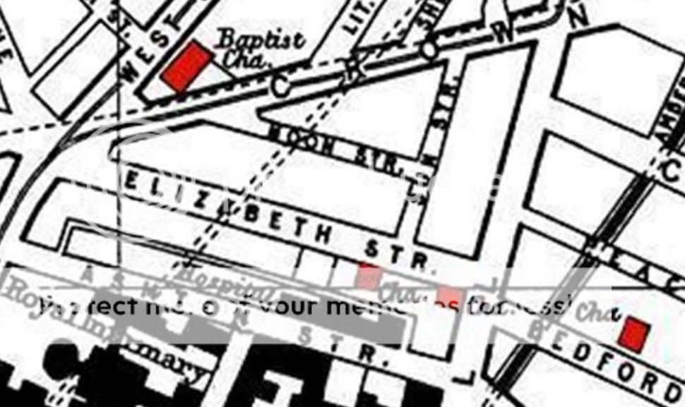
Thanks Marky that additional information confirms that Zion is one of the two little red squares at the southern end of Elizabeth Street on the LHP map.
Blue
Blue
Last edited by Blue70 on 12 Oct 2011 18:35, edited 1 time in total.
Member No. 8038
NIL SATIS NISI OPTIMUM
NIL SATIS NISI OPTIMUM
-
marky
The two red squares on this map represent Salem Independent Chapel (corner of Brownlow Hill/Elizabeth St) and Zion Chapel (Methodist) on Elizabeth St. almost opposite Sun St. junction.
http://www.liverpoolhistoryprojects.co. ... z/np79.htm
http://www.liverpoolhistoryprojects.co. ... z/np79.htm
Thanks Marky. Here is the map with the exact location identified by the name Zion:-
http://i431.photobucket.com/albums/qq33/Colgeor2/ZC.jpg
Blue
http://i431.photobucket.com/albums/qq33/Colgeor2/ZC.jpg
Blue
Member No. 8038
NIL SATIS NISI OPTIMUM
NIL SATIS NISI OPTIMUM