Does anyone know where, or has heard of Baplish Street was in 1839? I have a marriage certificate for my gt gt grandparents and this was where they were living. They were married at Holy Trinity Church, Liverpool.
thanks
Diane
Baplish Street, Liverpool

Can you post a small piece of the certificate for us to see the street name please, others might have some ideas.
Here's how to do it
http://liverpool-genealogy.org.uk/phpBB ... php?t=9817
and is that Holy Trinity in Wavertree or a different one? there are apparently three or four Holy Trinity's, including Everton, Anfield etc.
Here's how to do it
http://liverpool-genealogy.org.uk/phpBB ... php?t=9817
and is that Holy Trinity in Wavertree or a different one? there are apparently three or four Holy Trinity's, including Everton, Anfield etc.
MaryA
Our Facebook Page
Names - Lunt, Hall, Kent, Ayre, Forshaw, Parle, Lawrenson, Longford, Ennis, Bayley, Russell, Longworth, Baile
Any census info in this post is Crown Copyright, from National Archives
Our Facebook Page
Names - Lunt, Hall, Kent, Ayre, Forshaw, Parle, Lawrenson, Longford, Ennis, Bayley, Russell, Longworth, Baile
Any census info in this post is Crown Copyright, from National Archives
Baplish Street, Liverpool
Hi Mary
thanks for the help so far. You can view the certificate at
http://s1187.photobucket.com/albums/z39 ... poolgirl1/
I don't know which Holy Trinity Church it is unfortunately.
Diane
thanks for the help so far. You can view the certificate at
http://s1187.photobucket.com/albums/z39 ... poolgirl1/
I don't know which Holy Trinity Church it is unfortunately.
Diane
Baplish Street, Liverpool
Hi Katie
thanks so much, I think you could be right. Do you have Baptist Street on an old map? Can't see it on google maps.
Diane
thanks so much, I think you could be right. Do you have Baptist Street on an old map? Can't see it on google maps.
Diane
Have turned it around to make it easier to see

MaryA
Our Facebook Page
Names - Lunt, Hall, Kent, Ayre, Forshaw, Parle, Lawrenson, Longford, Ennis, Bayley, Russell, Longworth, Baile
Any census info in this post is Crown Copyright, from National Archives
Our Facebook Page
Names - Lunt, Hall, Kent, Ayre, Forshaw, Parle, Lawrenson, Longford, Ennis, Bayley, Russell, Longworth, Baile
Any census info in this post is Crown Copyright, from National Archives
As they were living in Cumberland Street, in the Dale Street area in the 1841 census I would suspect Katie has the correct church.
It doesn't seem to appear as late as 1899/1901 and I've checked the changed street names in 1865 Gores Directory and it's not there.
Definitely gone by 1881 as you can do a street search on that census.
It doesn't seem to appear as late as 1899/1901 and I've checked the changed street names in 1865 Gores Directory and it's not there.
Definitely gone by 1881 as you can do a street search on that census.
MaryA
Our Facebook Page
Names - Lunt, Hall, Kent, Ayre, Forshaw, Parle, Lawrenson, Longford, Ennis, Bayley, Russell, Longworth, Baile
Any census info in this post is Crown Copyright, from National Archives
Our Facebook Page
Names - Lunt, Hall, Kent, Ayre, Forshaw, Parle, Lawrenson, Longford, Ennis, Bayley, Russell, Longworth, Baile
Any census info in this post is Crown Copyright, from National Archives

Evening all!
In 1841 both Baptist Lane and Baptist Street are listed. They are also in 1861, 1871, and 1881. Both Islington area. For 1841 it is at HO107 - Piece:559 - Book/Folio:20/7 - Page:7.
In 1891 at RG12 / Piece: 2920 / Folio:21 / Page:35 there's Baptist Street, Liverpool.
Registration District: Liverpool; Sub District: Islington; Enumeration District: 13; Ecclesiastical Parish: Christchurch;
In 1901 both Baptist Lane and Baptist Street are listed. The latter at RG13 / Piece:3423 / Folio:111 / Page:18.
And ten years later Baptist Street is still on the menu. So it has to be on an old map.
The Holy Trinity Church location is marked on this map at: http://www.genuki.org.uk/cgi-bin/church ... AN,ID=2443
DS
DS
Member # 7743
RIP 20 April 2015
Emery, McAnaspie/McAnaspri etc, Fry, McGibbon/McKibbion etc, Burbage, Butler, Brady, Foulkes, Sarsfield, Moon [Bristol & Cornwall].
Census information is Crown Copyright http://www.nationalarchives.gov.uk/
Member # 7743
RIP 20 April 2015
Emery, McAnaspie/McAnaspri etc, Fry, McGibbon/McKibbion etc, Burbage, Butler, Brady, Foulkes, Sarsfield, Moon [Bristol & Cornwall].
Census information is Crown Copyright http://www.nationalarchives.gov.uk/
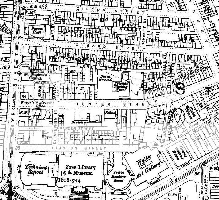
Thanks for that Dickiesam, this is the enumerator's walk from 1841, should identify the general area at least.
All that part of St Ann's Ward in the town of Liverpool comprising the North side of Gerard Street, Baptist Street, Baptist Lane, Bennett Street, Portland Place, and the East side of Byrom Street from Circus Street to Shaw's Brow.
Gerard Street can be seen on the map, East of Byrom Street and West of St Anne Street, so I think you can assume that all those streets were in that little area just above Gerard Street, which has all now been modernised.
MaryA
Our Facebook Page
Names - Lunt, Hall, Kent, Ayre, Forshaw, Parle, Lawrenson, Longford, Ennis, Bayley, Russell, Longworth, Baile
Any census info in this post is Crown Copyright, from National Archives
Our Facebook Page
Names - Lunt, Hall, Kent, Ayre, Forshaw, Parle, Lawrenson, Longford, Ennis, Bayley, Russell, Longworth, Baile
Any census info in this post is Crown Copyright, from National Archives

Baptist Street
Thanks so much everyone for all the info and maps, really helpful.
Diane
Diane