Eldon Street, James and Annie McLean
-
thenancollii
Eldon Street, James and Annie McLean
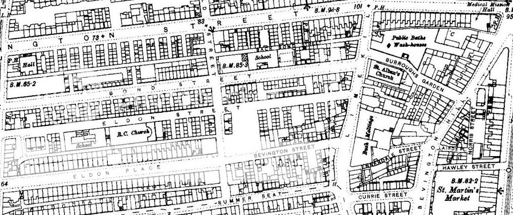
When James McLean married Annie Marshall at the Parish Church of St Albans, Bevington, Liverpool on 20th Feb 1887, his address is shown as 28 Eldon Place and she is shown as living next door at 26 Eldon Place (possibly as a convenient address to get married from as her home/family were from Birkenhead). He was linked to The Westmoreland Pub in that area. Do the church, the pub or the addresses still exist in that part of Liverpool? I am not a local and am having location problems, particulary with the church. Many thanks for any advice you can give regarding my predicament.

Hi
Here is a link to an old map of the area. The church was by the baths on Limekiln Lane. If you put your cursor over the red squares the names of the churches usually appear:-
http://www.liverpoolhistoryprojects.co. ... z/km79.htm
Here is a link to information about the church (it was bombed in the war and later demolished) if you click on the google link you can see a present-day map of the area:-
http://www.genuki.org.uk/cgi-bin/church ... 20Alban%20
Blue
Member No. 8038
NIL SATIS NISI OPTIMUM
NIL SATIS NISI OPTIMUM

Eldon Street
To find Eldon Street go to http://www.old-maps.co.uk/maps.html
Type Eldon Street Liverpool into the search box.
The post code for Eldon Street is L3 6HQ. Type that into Google Earth for a modern-day view of Eldon Street.
There's a photo of old Eldon Street
And here is another
Dickiesam
Type Eldon Street Liverpool into the search box.
The post code for Eldon Street is L3 6HQ. Type that into Google Earth for a modern-day view of Eldon Street.
There's a photo of old Eldon Street
And here is another
Dickiesam
DS
Member # 7743
RIP 20 April 2015
Emery, McAnaspie/McAnaspri etc, Fry, McGibbon/McKibbion etc, Burbage, Butler, Brady, Foulkes, Sarsfield, Moon [Bristol & Cornwall].
Census information is Crown Copyright http://www.nationalarchives.gov.uk/
Member # 7743
RIP 20 April 2015
Emery, McAnaspie/McAnaspri etc, Fry, McGibbon/McKibbion etc, Burbage, Butler, Brady, Foulkes, Sarsfield, Moon [Bristol & Cornwall].
Census information is Crown Copyright http://www.nationalarchives.gov.uk/

I love this new streetview on googlemaps, especially since I've now discovered that if I click the "link" icon at the top right it gives me a link to paste to show you what I've found.
Unfortunately the Eldon Estate has mostly been rebuilt and this picture shows you just where St Albans Church used to be, directly opposite Bond Street, Eldon Place has also been rebuilt.
From Limekiln Lane and you can see across they have kept the name Burroughs Garden also.
Unfortunately the Eldon Estate has mostly been rebuilt and this picture shows you just where St Albans Church used to be, directly opposite Bond Street, Eldon Place has also been rebuilt.
From Limekiln Lane and you can see across they have kept the name Burroughs Garden also.
MaryA
Our Facebook Page
Names - Lunt, Hall, Kent, Ayre, Forshaw, Parle, Lawrenson, Longford, Ennis, Bayley, Russell, Longworth, Baile
Any census info in this post is Crown Copyright, from National Archives
Our Facebook Page
Names - Lunt, Hall, Kent, Ayre, Forshaw, Parle, Lawrenson, Longford, Ennis, Bayley, Russell, Longworth, Baile
Any census info in this post is Crown Copyright, from National Archives
-
thenancollii