
I have ancestors living there at the time of the 1841 census - John and Fanny Irving and their brood of 7 children.
Myer's Place, Walton-on-the-Hill
Myer's Place, Walton-on-the-Hill
Please could someone with an old map tell me where Myer's Place was 
I have ancestors living there at the time of the 1841 census - John and Fanny Irving and their brood of 7 children.
I have ancestors living there at the time of the 1841 census - John and Fanny Irving and their brood of 7 children.
Member # 7779
Beaty, Mattinson, Gaddes, Irving (Cumbria & Liverpool) Greaves, Kelly, McQuinn, Anderton, Shaw (Liverpool)
Quinn, Whelan, McCraith, Finlay (Ireland)
Beaty, Mattinson, Gaddes, Irving (Cumbria & Liverpool) Greaves, Kelly, McQuinn, Anderton, Shaw (Liverpool)
Quinn, Whelan, McCraith, Finlay (Ireland)

Unfortunately the Enumerator's Description of his walk in 1841 doesn't seem to clarify as well as those in other years
"that part of the Township of West Derby known as Brunswick View with the Courts in it and Brunswick Road"
Brunswick Road can be seen http://www.liverpoolhistoryprojects.co. ... laz/N7.htm running northwards to meet West Derby Road at Low Hill, opposite the Necropolis Cemetery.
Any help? even though these maps are C1900.
MaryA
Our Facebook Page
Names - Lunt, Hall, Kent, Ayre, Forshaw, Parle, Lawrenson, Longford, Ennis, Bayley, Russell, Longworth, Baile
Any census info in this post is Crown Copyright, from National Archives
Our Facebook Page
Names - Lunt, Hall, Kent, Ayre, Forshaw, Parle, Lawrenson, Longford, Ennis, Bayley, Russell, Longworth, Baile
Any census info in this post is Crown Copyright, from National Archives

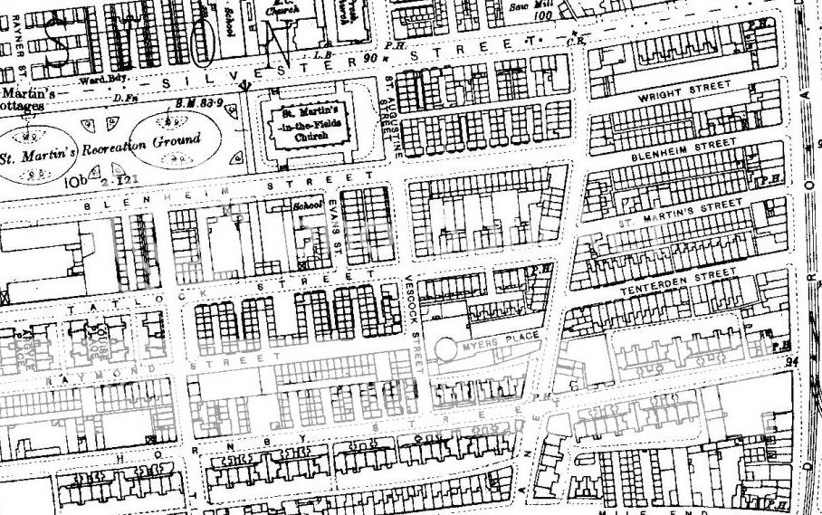
There was a Myers Street and a Myers Place on the 1841 Census here is a map showing Myers Street (it's bottom/centre on the map):-
http://www.liverpoolhistoryprojects.co. ... z/rt46.htm
Blue
http://www.liverpoolhistoryprojects.co. ... z/rt46.htm
Blue
Member No. 8038
NIL SATIS NISI OPTIMUM
NIL SATIS NISI OPTIMUM

Myers Place
I've a feeling Myers Place wasn't in or off Myers Street. The map from Blue shows Wavertree Park but the mention of Myers Place on the LOPC site, in a description of the boundary of the Parish Of St Martins-In-The-Field in 1909, puts it in the Scottie Road/Vauxhall Road/Tenterden Street area: http://www.lan-opc.org.uk/Liverpool/Vau ... index.html
This might help give you an idea of what Myers Place was like and where it was 'adjacent to'.
The 1851 lists 4 households in Myers Place across 3 dwellings. They are on
RG number: HO107 / Piece:2177 / Folio:509 / Pages 2 and 3.
Enjoy the walk-about!:arrow::lol:
DS
This might help give you an idea of what Myers Place was like and where it was 'adjacent to'.
The 1851 lists 4 households in Myers Place across 3 dwellings. They are on
RG number: HO107 / Piece:2177 / Folio:509 / Pages 2 and 3.
Enjoy the walk-about!:arrow::lol:
DS
DS
Member # 7743
RIP 20 April 2015
Emery, McAnaspie/McAnaspri etc, Fry, McGibbon/McKibbion etc, Burbage, Butler, Brady, Foulkes, Sarsfield, Moon [Bristol & Cornwall].
Census information is Crown Copyright http://www.nationalarchives.gov.uk/
Member # 7743
RIP 20 April 2015
Emery, McAnaspie/McAnaspri etc, Fry, McGibbon/McKibbion etc, Burbage, Butler, Brady, Foulkes, Sarsfield, Moon [Bristol & Cornwall].
Census information is Crown Copyright http://www.nationalarchives.gov.uk/

Hi All 
The only Myers Place in 1853 Directory was off Limekiln Lane.
Sorry no John Irving listed.
Tina
The only Myers Place in 1853 Directory was off Limekiln Lane.
Sorry no John Irving listed.
Tina
- Tina
Cornthwaite,Milburn,Coll,Gaffney,Pearce,Singleton,Hazlehurst,Cuthbert,Mackintosh,McAllister,Morana, Corfield
Any census/bmd information within this post is Crown Copyright from http://www.nationalarchives.gov.uk/
Thanks All for your help!
By 1851 the Irvings had moved to No. 4 Court, Brunswick View, and they moved from there to 52 Gregson Street, so I guess it would seem likely that Myer's Place was somewhere in that vicinity ... they seem to have oscillated around a fairly small area!
Strange that there should have been a Myer's Place off Limekiln Lane too, though.
Member # 7779
Beaty, Mattinson, Gaddes, Irving (Cumbria & Liverpool) Greaves, Kelly, McQuinn, Anderton, Shaw (Liverpool)
Quinn, Whelan, McCraith, Finlay (Ireland)
Beaty, Mattinson, Gaddes, Irving (Cumbria & Liverpool) Greaves, Kelly, McQuinn, Anderton, Shaw (Liverpool)
Quinn, Whelan, McCraith, Finlay (Ireland)
There was also another down Smithdown Lane way, but I think yours probably vanished quite early, definitely near Brunswick View/Road as they were the next entries in the census.
MaryA
Our Facebook Page
Names - Lunt, Hall, Kent, Ayre, Forshaw, Parle, Lawrenson, Longford, Ennis, Bayley, Russell, Longworth, Baile
Any census info in this post is Crown Copyright, from National Archives
Our Facebook Page
Names - Lunt, Hall, Kent, Ayre, Forshaw, Parle, Lawrenson, Longford, Ennis, Bayley, Russell, Longworth, Baile
Any census info in this post is Crown Copyright, from National Archives
Ah, thanks MaryA ... I'm not subscribed to any genealogy sites at the moment so I've not been able to follow up the research I've done previously.
There's a Myer's Road in Crosby/Waterloo too ... so I guess Myer must have been an influential chap.
There's a Myer's Road in Crosby/Waterloo too ... so I guess Myer must have been an influential chap.
Member # 7779
Beaty, Mattinson, Gaddes, Irving (Cumbria & Liverpool) Greaves, Kelly, McQuinn, Anderton, Shaw (Liverpool)
Quinn, Whelan, McCraith, Finlay (Ireland)
Beaty, Mattinson, Gaddes, Irving (Cumbria & Liverpool) Greaves, Kelly, McQuinn, Anderton, Shaw (Liverpool)
Quinn, Whelan, McCraith, Finlay (Ireland)
Spitting chips Zed because I can't get Brunswick Rd in the Old Ordnance Maps.
I've tried coming from W Dby, Everton, City, Wavertree, each time the grid ends just before there
I think I'm getting mad because as a kiddie I lived in Low Hill, tagged along with Ma to Brunswick Rd which then became W Dby Road and we had rellies in Gregson St......
The Myer's place I found in 1853 is not yours.
Tina
- Tina
Cornthwaite,Milburn,Coll,Gaffney,Pearce,Singleton,Hazlehurst,Cuthbert,Mackintosh,McAllister,Morana, Corfield
Any census/bmd information within this post is Crown Copyright from http://www.nationalarchives.gov.uk/
That's strange Tina ...
Unfortunately I don't have any old OS maps myself, but the link that Mary posted (c1900 map) has Gregson St, Brunswick Rd. -> West Derby Rd.
http://www.liverpoolhistoryprojects.co. ... laz/N7.htm
Quite a few of my lot lived in various numbers of Napier St. as well as Gregson St. I've seen a couple of photos pre 'slum clearance' (LRO) and was surprised to see how large some of the old properties were ... I'd imagined them all to be tiny terraced houses (2-up, 2-down).
Off the subject ... I was looking at the burial records for The Necropolis: what an alarming number of infants died as a result of "teething". How does that happen?
Member # 7779
Beaty, Mattinson, Gaddes, Irving (Cumbria & Liverpool) Greaves, Kelly, McQuinn, Anderton, Shaw (Liverpool)
Quinn, Whelan, McCraith, Finlay (Ireland)
Beaty, Mattinson, Gaddes, Irving (Cumbria & Liverpool) Greaves, Kelly, McQuinn, Anderton, Shaw (Liverpool)
Quinn, Whelan, McCraith, Finlay (Ireland)
Dentition (teething)
It was once a common cause of death in babies and young children. Babies have no control over their body temperature and prolonged pain and crying would give them a very high fever. Theyc ould also suffer from bronchitis, diarrhoea, convulsions or thruch from which they could subsequently die. Babies would also be given rattles, rings or pieces of bone to chew on and their fingers would not always be clean when they sucked them, all of which could lead to infections from which they could die.
From A dictionary of medical & related terms for the family historian by Joan E Grundy
Hilary
Ed Officer
Hilary
5334
5334
-
chiefsub68
- Non Member
- Posts: 62
- Joined: 13 Apr 2007 11:10
Maps of Liverpool
I'm now kicking myself ... I was at Spitalfields market in London last month and found a stall with about 80 large scale maps of central Liverpool, all printed on calico. They dated from 1880 and seemed to have been used by a disaster control unit; they were stamped "Superseded 1969". I was on my way to work and couldn't have carried them (each was about 3ft 6in by 2ft, so I didn't even ask the price.
Coooo ... there are Liverpool historians who would have given a small fortune for those!
I'm not sure what 'superseded 1969' means ... the slum clearances were underway in the 1960s so perhaps it was something to do with that? (Particularly if the maps had belonged to the Council).
I'm not sure what 'superseded 1969' means ... the slum clearances were underway in the 1960s so perhaps it was something to do with that? (Particularly if the maps had belonged to the Council).
Member # 7779
Beaty, Mattinson, Gaddes, Irving (Cumbria & Liverpool) Greaves, Kelly, McQuinn, Anderton, Shaw (Liverpool)
Quinn, Whelan, McCraith, Finlay (Ireland)
Beaty, Mattinson, Gaddes, Irving (Cumbria & Liverpool) Greaves, Kelly, McQuinn, Anderton, Shaw (Liverpool)
Quinn, Whelan, McCraith, Finlay (Ireland)