Hi,
Has anyone come across Dryam Street, Liverpool in their research?
I have a Liverpool RC marriage transcript from 1886. One of the witnesses address has been transcribed as Dryam Street and the handwritten copy definitely looks like Dryam too. I just can't seem to find any references to it from 1881/1891 online and it isn't on google maps as a current street either.
Thanks
Liverpool Street around 1880
-
BarrattFamily
- Non Member
- Posts: 79
- Joined: 14 Jan 2009 22:42
Liverpool Street around 1880
Leonie
Member No: 7862
Liverpool Names - Barratt, McEvoy, Willoughby
Member No: 7862
Liverpool Names - Barratt, McEvoy, Willoughby

I'm wondering about Byrom Street, but would prefer more information. Could you please post the details from the transcript ie what church the marriage took place in etc. and if you scan the original we could see what has been written and try to help that way.
Details for posting a photograph in your message are here
Details for posting a photograph in your message are here
MaryA
Our Facebook Page
Names - Lunt, Hall, Kent, Ayre, Forshaw, Parle, Lawrenson, Longford, Ennis, Bayley, Russell, Longworth, Baile
Any census info in this post is Crown Copyright, from National Archives
Our Facebook Page
Names - Lunt, Hall, Kent, Ayre, Forshaw, Parle, Lawrenson, Longford, Ennis, Bayley, Russell, Longworth, Baile
Any census info in this post is Crown Copyright, from National Archives

Hi
I went through all the Directories I have, no trace of street.
Tina
I went through all the Directories I have, no trace of street.
Tina
- Tina
Cornthwaite,Milburn,Coll,Gaffney,Pearce,Singleton,Hazlehurst,Cuthbert,Mackintosh,McAllister,Morana, Corfield
Any census/bmd information within this post is Crown Copyright from http://www.nationalarchives.gov.uk/
-
BarrattFamily
- Non Member
- Posts: 79
- Joined: 14 Jan 2009 22:42
-
BarrattFamily
- Non Member
- Posts: 79
- Joined: 14 Jan 2009 22:42
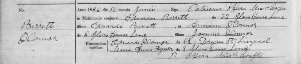
1886 – 368 (ST OSWALD RC, OLD SWAN)
13th June 1886
Were married EDWARD BARRETT of 22 GLASS HOUSE LANE
Son of EDWARD BARRETT
And ANN O’CONNOR of 8 GLASS HOUSE LANE
Daughter of JOHN O’CONNOR
Witnesses EDWARD O’CONNOR of 63 DRYAM ST, LIVERPOOL
MARY ANN FERGUSON of 8 GLASS HOUSE LANE
13th June 1886
Were married EDWARD BARRETT of 22 GLASS HOUSE LANE
Son of EDWARD BARRETT
And ANN O’CONNOR of 8 GLASS HOUSE LANE
Daughter of JOHN O’CONNOR
Witnesses EDWARD O’CONNOR of 63 DRYAM ST, LIVERPOOL
MARY ANN FERGUSON of 8 GLASS HOUSE LANE
Leonie
Member No: 7862
Liverpool Names - Barratt, McEvoy, Willoughby
Member No: 7862
Liverpool Names - Barratt, McEvoy, Willoughby
I think it is DRYDEN Street, which currently is between Scotland Road and Great Homer Street, funny I originally suggested Byrom Street since that's close by and actually nowhere near where Glass House Lane would be.
MaryA
Our Facebook Page
Names - Lunt, Hall, Kent, Ayre, Forshaw, Parle, Lawrenson, Longford, Ennis, Bayley, Russell, Longworth, Baile
Any census info in this post is Crown Copyright, from National Archives
Our Facebook Page
Names - Lunt, Hall, Kent, Ayre, Forshaw, Parle, Lawrenson, Longford, Ennis, Bayley, Russell, Longworth, Baile
Any census info in this post is Crown Copyright, from National Archives
I really wish we could find Glass House Lane for you.
It looks like Dryden St?
What do the crew think please?
Tina
It looks like Dryden St?
What do the crew think please?
Tina
- Tina
Cornthwaite,Milburn,Coll,Gaffney,Pearce,Singleton,Hazlehurst,Cuthbert,Mackintosh,McAllister,Morana, Corfield
Any census/bmd information within this post is Crown Copyright from http://www.nationalarchives.gov.uk/
In 1881 62 Dryden Street appears to be a boarding house with many families and individuals living in it, so it would make sense.
Surely Glass House Lane has to be near the Glasshouse pub/hotel, especially since the marriage was at St Oswalds very close by.
Surely Glass House Lane has to be near the Glasshouse pub/hotel, especially since the marriage was at St Oswalds very close by.
MaryA
Our Facebook Page
Names - Lunt, Hall, Kent, Ayre, Forshaw, Parle, Lawrenson, Longford, Ennis, Bayley, Russell, Longworth, Baile
Any census info in this post is Crown Copyright, from National Archives
Our Facebook Page
Names - Lunt, Hall, Kent, Ayre, Forshaw, Parle, Lawrenson, Longford, Ennis, Bayley, Russell, Longworth, Baile
Any census info in this post is Crown Copyright, from National Archives
-
BarrattFamily
- Non Member
- Posts: 79
- Joined: 14 Jan 2009 22:42
Thank you so much Mary & Tina. Trying to trace some of the witnesses from the marriages & baptisms that I bought from Liverpool History Projects. In the past witnesses have led me to discover more clues so I'm keeping my fingers crossed.
Do either of you know what made someone choose a godparent in those days? Was it usually a family member or just someone they knew who could financially look after their children if something happened to them? I don't know much about baptisms.
Do either of you know what made someone choose a godparent in those days? Was it usually a family member or just someone they knew who could financially look after their children if something happened to them? I don't know much about baptisms.
Leonie
Member No: 7862
Liverpool Names - Barratt, McEvoy, Willoughby
Member No: 7862
Liverpool Names - Barratt, McEvoy, Willoughby
-
BarrattFamily
- Non Member
- Posts: 79
- Joined: 14 Jan 2009 22:42
I'm trying to get my bearings... Am I right in thinking Dryden St, Scotland Road, Great Homer St and the area where the Glasshouse pub is are all very close to one another?
The 3 children of Edward & Annie Barratt (O'Connor) were all married at St Mary of the Angels and I saw a clip on youtube recently where a folk singer was singing about the church and it's 100 year history. He mentions Great Homer St & Scotland Road throughout the song.
[http://www.youtube.com/watch?v=E3LimvFuw10]
The family stories are that when Annie died she was buried in her Franciscan robes. She wasn't a nun but was like a 'lay' person (if that is the right term) for the church. Rupert Terrace, Garden Lane must be close to because the family say she lived close to the church that she helped out at.
I'm so looking forward to seeing all of these places when we come over in July. When I'm back home in August I will know exactly what area you are talking about because I will have been there!!!!
Thanks again.
Leonie
Member No: 7862
Liverpool Names - Barratt, McEvoy, Willoughby
Member No: 7862
Liverpool Names - Barratt, McEvoy, Willoughby
If you use www.maps.google.co.uk you will see that Great Homer Street, Scotland Road, Dryden Street and Fox Street where the church of St Mary of the Angels is, are all close to each other. Garden Lane, off Everton Brow is across from Prince Rupert's Tower, used as a lock-up, also not very far away from the other streets mentioned above.
Enter another destination of St Oswald's Street, where that Church is, and you will see that it is about three miles away. The Glasshouse public house is nearby to St Oswald's Street.
Enter another destination of St Oswald's Street, where that Church is, and you will see that it is about three miles away. The Glasshouse public house is nearby to St Oswald's Street.
MaryA
Our Facebook Page
Names - Lunt, Hall, Kent, Ayre, Forshaw, Parle, Lawrenson, Longford, Ennis, Bayley, Russell, Longworth, Baile
Any census info in this post is Crown Copyright, from National Archives
Our Facebook Page
Names - Lunt, Hall, Kent, Ayre, Forshaw, Parle, Lawrenson, Longford, Ennis, Bayley, Russell, Longworth, Baile
Any census info in this post is Crown Copyright, from National Archives
-
BarrattFamily
- Non Member
- Posts: 79
- Joined: 14 Jan 2009 22:42
Thanks Mary for taking the time to do that for me. I'll get on Google maps and check it out. I have a tiny laptop with one of those little screens. It's very handy for carting around everywhere but not very practical for viewing on the screen. I need to buy both an old & a new map of Liverpool one of these days. Maybe when I'm over there.
I really appreciate your help. Thanks.
I really appreciate your help. Thanks.
Leonie
Member No: 7862
Liverpool Names - Barratt, McEvoy, Willoughby
Member No: 7862
Liverpool Names - Barratt, McEvoy, Willoughby
I have some 1st edition Ordnance Survey maps 25 inch to the mile produced around 1890. I have been looking on them for Glasshouse Lane.
Assuming that for them to have been married at St Oswalds Old Swan I started around that area. I have discovered that the pub the HGlasshouse was named after the glassworks that used to be there. These were on Mill Lane at Old Swan. Using the other street names around Glasshouse Lane in 1891 - Springfield Street and Hurst Street I was able to find both of them running between St Oswald Street and Mill Lane. Husrst Street still exists on the present day maps. Within the Glass Works there appears to be a small unamed street possibly Glasshouse Lane? I think you would need a slightly later map than I have as it appears to have been the timne Old Swan was developing. At least you can now position it's approximate position now.
Maybe try Alan Godfrey maps to see if they have one around 1900.
Hilary
Ed officer
PS someone must have a connection to this parish for them to be married there.
Hilary, our Education Officer will advise you best on an old map. It might be a good idea if you were to give some idea of what date would be best for you.
MaryA
Our Facebook Page
Names - Lunt, Hall, Kent, Ayre, Forshaw, Parle, Lawrenson, Longford, Ennis, Bayley, Russell, Longworth, Baile
Any census info in this post is Crown Copyright, from National Archives
Our Facebook Page
Names - Lunt, Hall, Kent, Ayre, Forshaw, Parle, Lawrenson, Longford, Ennis, Bayley, Russell, Longworth, Baile
Any census info in this post is Crown Copyright, from National Archives
Which map to buy?
The problem is that Glasshouse Lane is not marked on any of the maps I have. I have looked on the Ordnance Survey 1st edition 6 inch to the mile produced around 1850 and again I can locate Hurst Street and Springfield Street but no Glasshouse Lane. The glassworks is there and the tavern. The same problem occurs on the 1st Edition 25 inch to the mile maps of around 1890 see above.
I've suggested the Alan Godfrey maps as they are the probably cheaper alternative. The only place I've ever got copies of the full sheets mentioned above is via Record Offices.
Alan Godfrey is at www.alangodfreymaps.co.uk
I would suggest this one for an overview of Old Swan
Here are the details of maps for Knotty Ash:
Lancashire Sheet 106.12 Knotty Ash & Old Swan 1906 - published 1993; intro by Kay Parrott
This detailed map covers the area of east Liverpool around Old Swan and Knotty Ash. Coverage stretches from Church Road Stanley eastward to St John's Church Knotty Ash; and from Russian Drive southward to Oak Hill Park. Features include Knotty Ash, Old Swan Ward, Stoney Croft, Oakhill Park, Old Swan, Stanley (East), Highfield Infirmary, Old Swan Rope Works, Liverpool Cattle Market, tramways, St Oswald's RC church, Derwent Square, Borax Works, Moss Farm, Fir Grove Farm, Cheshire Lines Railway with Knotty Ash & Stanley station, Hebrew Cemetery, Highfield House, Little Bongs, The Old Hall etc. On the reverse we include street directory entries for Green Lane, Leinster Road, Prescot Road, Russian Drive, St Oswald's Street, Sandstone Road, Thomas Lane.
This map links up with sheet 106.12 West Derby to the north, 106.11 Newsham Park to the west, 106.16 Wavertree to the south.
and for Dryden Street possibly this one I think covers the area
Here are the details of maps for Liverpool (North):
Lancashire Sheet 106.10 Liverpool (North) 1906 - published 1990; intro by Naomi Evetts
This detailed map is double-sided to provide maximum coverage. The main map, 106.10, covers a major northern part of the city, with coverage stretching from King Edward Street eastward to Everton Road, and from Conway Street southward to William Brown Street. This is a very busy map, but features include Walker Art Gallery, Library & Museum, Tobacco Manufactory, Wholesale Fruit Market, Victoria Square, St Anthony's RC church, tramways, St Augustine's church, Rupert Lane Barracks, Liverpool College, western part of Everton, St Anne's Ward, South Scotland Ward, Vauxhall Ward, LYR railway with Exchange station, Exchange Station Junction, Great Howard St Goods Station, LNWR Waterloo Goods Station with tunnel shown, David Lewis Northern Hospital, Leeds & Liverpool Canal etc. On the reverse we include adjacent sheet 106.09 extending coverage westward to the docks, incl Nelson Dock, Collingwood Dock, Salisbury Dock, Clarence Dock, Trafalgar Dock, Victoria Dock, Waterloo Docks, part of Prince's Dock, with part of Riverside Railway and Overhead Railway. Street directory entries for Everton Brow, Great Homer Street and Great Howard Street are also included.
This map links up with sheet 106.06 Kirkdale to the north, 106.11 Newsham Park to the east, 106.14
They have an on line shop
Hope this helps
Hilary
Ed Officer
-
BarrattFamily
- Non Member
- Posts: 79
- Joined: 14 Jan 2009 22:42
Thanks Mary & Hilary,
Mary excuse me for being a bit thick but what did you mean when you said -
Hilary the info about the maps is so helpful for me. I will check the Alan Godfrey site out over a morning coffee.
It really helps to have people that know what they're talking about on this forum giving me this advice. I'm learning every day!!!
Mary excuse me for being a bit thick but what did you mean when you said -
I haven't researched about parishes - guess what I'm doing today.PS someone must have a connection to this parish for them to be married there.
Hilary the info about the maps is so helpful for me. I will check the Alan Godfrey site out over a morning coffee.
It really helps to have people that know what they're talking about on this forum giving me this advice. I'm learning every day!!!
Leonie
Member No: 7862
Liverpool Names - Barratt, McEvoy, Willoughby
Member No: 7862
Liverpool Names - Barratt, McEvoy, Willoughby
Hi
What I meant was that someone must have been living in the parish of St Oswald for the marriage to take place there. That appears to have been Edward. As Old Swan was very much on the edge of Liverpool I wonder if his family has connections there or why did he live there?
People usually married in the parish where they lived otherwise the banns had to be called in 2 churches and that cost money!! Sometimes people would give the same address not that they were cohabiting but it was cheaper that way.
On my parents' marriage certificate my mother's address is not actually her address. I learnt a couple of years ago that was because her actual address wan't in the parish of the church they attended so they gave a different address that was! My father was in the army at the time.
Hilary
Ed Offcier
Last edited by Hilary on 16 Mar 2010 21:24, edited 1 time in total.
-
BarrattFamily
- Non Member
- Posts: 79
- Joined: 14 Jan 2009 22:42
So many questions......
I wonder when the Glasshouse closed down? I assume it was just to make bottles.
In the 1911 census Ann Barratt and her 2 daughters are all 'bottle workers' at 'Mineral Water Works'. When her son Edward marries in 1920 his wife was a 'bottle washer'. From 1911 to 1920 they were at 5 Rupert Terrace, Garden Lane, Everton Brow.
Leonie
Member No: 7862
Liverpool Names - Barratt, McEvoy, Willoughby
Member No: 7862
Liverpool Names - Barratt, McEvoy, Willoughby
Glasshosue is the name of the pub
The glass works were on the map of around 1850 and on the map of around 1890. Garden Lane was away from Old Swan. There would have been a number of bottle makers and bottling factories all over the place.
When you have some maps ypu will be able to identify them.
Someone with directories may be able to tell you more. Incidentally the indformation I found about the Glass works came from a small book called Lost Villages of Liverpool Part One. You can buy them from the Society and maps as well. Just look on the publications page.
Hilary
Ed Officer
-
BarrattFamily
- Non Member
- Posts: 79
- Joined: 14 Jan 2009 22:42
Thanks Hilary for clearing that up. Sorry Mary for quoting you!
I do have the GRO marriage certificate and Edward's father was Edward Barratt (deceased) - cabinet maker.
Edward's address was 22 Glasshouse Lane & Anne O'Connors was 8 Glasshouse Lane. One of their witnesses - Mary A Ferguson - also had 8 Glasshouse Lane as her address with the other witness at 62 Dryden St.
Leonie
Member No: 7862
Liverpool Names - Barratt, McEvoy, Willoughby
Member No: 7862
Liverpool Names - Barratt, McEvoy, Willoughby