Which map to buy?
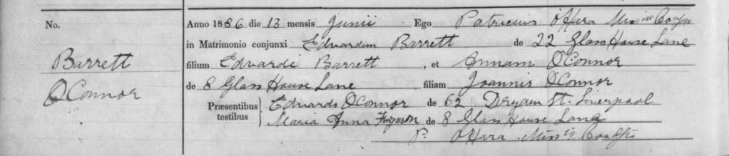
The problem is that Glasshouse Lane is not marked on any of the maps I have. I have looked on the Ordnance Survey 1st edition 6 inch to the mile produced around 1850 and again I can locate Hurst Street and Springfield Street but no Glasshouse Lane. The glassworks is there and the tavern. The same problem occurs on the 1st Edition 25 inch to the mile maps of around 1890 see above.
I've suggested the Alan Godfrey maps as they are the probably cheaper alternative. The only place I've ever got copies of the full sheets mentioned above is via Record Offices.
Alan Godfrey is at
www.alangodfreymaps.co.uk
I would suggest this one for an overview of Old Swan
Here are the details of maps for Knotty Ash:
Lancashire Sheet 106.12 Knotty Ash & Old Swan 1906 - published 1993; intro by Kay Parrott
This detailed map covers the area of east Liverpool around Old Swan and Knotty Ash. Coverage stretches from Church Road Stanley eastward to St John's Church Knotty Ash; and from Russian Drive southward to Oak Hill Park. Features include Knotty Ash, Old Swan Ward, Stoney Croft, Oakhill Park, Old Swan, Stanley (East), Highfield Infirmary, Old Swan Rope Works, Liverpool Cattle Market, tramways, St Oswald's RC church, Derwent Square, Borax Works, Moss Farm, Fir Grove Farm, Cheshire Lines Railway with Knotty Ash & Stanley station, Hebrew Cemetery, Highfield House, Little Bongs, The Old Hall etc. On the reverse we include street directory entries for Green Lane, Leinster Road, Prescot Road, Russian Drive, St Oswald's Street, Sandstone Road, Thomas Lane.
This map links up with sheet 106.12 West Derby to the north, 106.11 Newsham Park to the west, 106.16 Wavertree to the south.
and for Dryden Street possibly this one I think covers the area
Here are the details of maps for Liverpool (North):
Lancashire Sheet 106.10 Liverpool (North) 1906 - published 1990; intro by Naomi Evetts
This detailed map is double-sided to provide maximum coverage. The main map, 106.10, covers a major northern part of the city, with coverage stretching from King Edward Street eastward to Everton Road, and from Conway Street southward to William Brown Street. This is a very busy map, but features include Walker Art Gallery, Library & Museum, Tobacco Manufactory, Wholesale Fruit Market, Victoria Square, St Anthony's RC church, tramways, St Augustine's church, Rupert Lane Barracks, Liverpool College, western part of Everton, St Anne's Ward, South Scotland Ward, Vauxhall Ward, LYR railway with Exchange station, Exchange Station Junction, Great Howard St Goods Station, LNWR Waterloo Goods Station with tunnel shown, David Lewis Northern Hospital, Leeds & Liverpool Canal etc. On the reverse we include adjacent sheet 106.09 extending coverage westward to the docks, incl Nelson Dock, Collingwood Dock, Salisbury Dock, Clarence Dock, Trafalgar Dock, Victoria Dock, Waterloo Docks, part of Prince's Dock, with part of Riverside Railway and Overhead Railway. Street directory entries for Everton Brow, Great Homer Street and Great Howard Street are also included.
This map links up with sheet 106.06 Kirkdale to the north, 106.11 Newsham Park to the east, 106.14
They have an on line shop
Hope this helps
Hilary
Ed Officer