Page 1 of 1
Christ Church (Hunter Street) Kensington.
Posted: 04 Mar 2010 16:58
by GHOME
Hi Can anyone point me in the right direction regarding a Picture or map image of where exactly Christ Church (Hunter Street) Kensington I understand It was closed 1918.

Posted: 04 Mar 2010 17:43
by erika
Posted: 04 Mar 2010 18:03
by daggers
There is a picture of Ch Ch Hunter Street on page 14 in 'Churches of Liverpool' by David Lewis, which you can see if you visit the Liverpool Record Office. [It was behind the Walker Art Gallery in the area which has been used for the Churchill Way flyover etc.]
Its records are there under ref 283 CHR.
D
Posted: 05 Mar 2010 04:56
by Tina
MAP
Posted: 05 Mar 2010 05:34
by Tina
Penny has just dropped

2 churches on the go.
Hunter St is not Kensington it was Lpool 3.
The vicar of Christ Church in Kensington 1938 was living at 28 Fairfield Cresc.
No church listed in Hunter St.
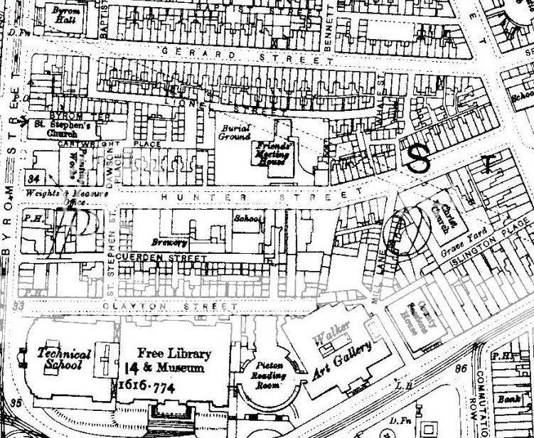
Here's a link to the area, as Daggers said, behind the Art Gallery, you will see the church between Hunter St & Islington Place.
Cheers
Tina
http://www.british-history.ac.uk/mapshe ... =148&y=248
Hunter Street
Posted: 16 Mar 2011 22:44
by adelongshanks
The church was on the site of Liverpool Polytechnic now John Moores University. It was situated where the the building is closest to the flyover. students used to say that end of the building was haunted.
Posted: 17 Mar 2011 00:22
by Blue70
adelongshanks wrote:The church was on the site of Liverpool Polytechnic now John Moores University. It was situated where the the building is closest to the flyover. students used to say that end of the building was haunted.
Do you mean St Stephen's Church Byrom Street?
Blue
Posted: 17 Mar 2011 08:25
by daggers
Blue
No, Christ Church is also on your map, below the big 'S', and to the right of Mill Lane.
D
Posted: 17 Mar 2011 08:54
by MaryA
I never knew just where it was before, nice to have that guidance, thanks. Compare with a modern map
Hunter Street
maybe the church was under that little cluster of trees.
Posted: 17 Mar 2011 09:15
by PJLong
Wow....best map I've seen yet of where my lot lived (those darn Lindsay's) Does anyone know the name of the school under the "R" of Hunter St? If my lot lived at no 1 Dawson Place could I assume that may have been the school they went to?
Cheers all,Pauline.
Posted: 17 Mar 2011 10:17
by Blue70
daggers wrote:Blue
No, Christ Church is also on your map, below the big 'S', and to the right of Mill Lane.
D
Hi Daggers
I was replying to adelongshanks I think the church referred to in that post was St Stephen's Church Byrom Street.
Regards,
Blue
Hunter Street school
Posted: 17 Mar 2011 16:42
by dickiesam
PJLong wrote:Wow....best map I've seen yet of where my lot lived (those darn Lindsay's) Does anyone know the name of the school under the "R" of Hunter St? If my lot lived at no 1 Dawson Place could I assume that may have been the school they went to?
Cheers all,Pauline.
My dad was born and dragged up in Hunter Street. He went to Christ Church school as a young lad. This a class photo circa 1916 of what looks like Standard V.. He's in the centre, standing in front of the left shoulder of a girl in a white dress with a narrow dark belt. The back row are standing on chairs.

DS
Posted: 17 Mar 2011 17:28
by PJLong
Oh my..........There's a possibility of one of my lot being in there Prof'! Not my grandad as he and his brother had been sent to Dumfries Industrial School in 1913. Gosh, fab photo! Love the massive bow in the lass's hair next but one to your Da'.
Hope you've had a good St Patrick's Day.
Cheers, Pauline.
Posted: 18 Mar 2011 08:45
by MaryA
Hey DS send that in to the Journal, it's perfect for wider viewing, somebody might recognise their parents.