Page 1 of 1
Mystery cricket ground in Liverpool ?
Posted: 15 May 2009 12:25
by daggers
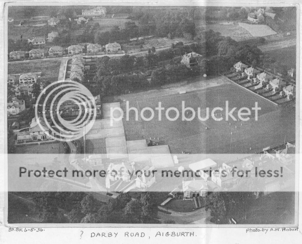
The Liverpool Record Office holds a photo filed with 'Aigburth Vale'. It is an aerial view of a cricket ground, and the mount is marked 'Darby Road Aigburth'. The only ground I know of there was the former Lewis's/Bon Marche site, Ranelagh Park, but this does not fit.
Can anyone throw any light on this rather dim pic?
Daggers
PS My attempt at pasting a copy has failed! Await further attempts, please.
Posted: 15 May 2009 12:34
by Tina
Hi Daggers
I've been told that Elders Fyffes had a sports ground in Darby Road Allerton before WW2.
Not sure if this is of help.
Best wishes
Tina
Posted: 15 May 2009 12:49
by MaryA
I'm sorry I don't know the area but I looked on
www.maps.google.co.uk and entered Darby Road, Allerton and it offered me Garston, would this be the right place?
As you have an aerial photograph and googlemaps offers you a satellite choice, maybe you could match up a landmark? I saw two large open spaces but don't know if they would be in the right place - one is on the other side of Aigburth Road, bounded by Beechwood Road and Riversdale Road, the other further east is bounded by Clarendon Road, Long Lane, Whitehedge Road and Garston Old Road.
If I have the wrong place, maybe you would be able to find it doing a similar exercise.
Posted: 15 May 2009 20:08
by daggers
Tina and MaryA
Thanks for suggestions which are always welcome. I have done a bit of map comparison and know the area well, but the housing layout does not fit with the ones you suggest. I suspect that the Elders & Fyffes ground may be the one used later by Lewis's/Bon Marche, but will try to find someone even older than I who might remember.
[Can anyone else remember when we could go into Garston Docks and see the Fyffes bananas being unloaded? Pre-war before Security and other factors stopped the fun.]
I shall try re-loading the photo via p/bucket.
D
Posted: 15 May 2009 20:38
by daggers
Posted: 15 May 2009 20:58
by Hilary
Hi
I don't know that area at all well and note that someone has written ? Darby Road Aignurth onit.
I wondered about the large house next door is it Sudeley House or have I gone completey crackers! If so would it now be something to do with the university?
We need a 1930s map!
Ed Officer
Posted: 15 May 2009 22:50
by daggers
The general layout does not match the area around Sudley. The question mark before the caption 'Darby Road' has been added later in pencil, and the photographer's details have not led anywhere.. Yes, EO, I shall try the OS maps at Wm Brown Street next, hoping they have a mid-1930s large scale version.
D
Posted: 16 May 2009 02:52
by northmeols
Posted: 16 May 2009 11:23
by daggers
Thanks for posting the pic, Susan - I have not had to post one before and it looks far better than the long p/bucket code!
D
Posted: 16 May 2009 20:41
by northmeols
its easy daggers.....under your photo on PB it will bring up ways to insert...select bottom one that says image right click..copy then paste in message
Posted: 16 May 2009 21:41
by MaryA
Ooops sorry, I fixed the link before reading the rest of the thread, thanks for that Susan.