Page 1 of 1
1851 census - St Anne Street puzzle
Posted: 18 Jan 2015 11:09
by daggers
I have been looking at the image of the entry for John Grant Murray and family which is on HO107/2185/360/28. The address is given as 63 St Ann Street, but surrounding entries are all for Myrtle Street. There are fuller lists for St Ann(e) Street later in the sequence, some with the 'e' and some without.
Was there a St Ann(e) Street anywhere near Myrtle Street at that time? I know of the current street, to the north of Islington, but these entries seem far apart. I could not find a street list in my search.
All suggestions welcome.
Daggers
Re: 1851 census - St Anne Street puzzle
Posted: 18 Jan 2015 11:48
by MaryA
Re: 1851 census - St Anne Street puzzle
Posted: 18 Jan 2015 11:55
by MaryA
Page one of the set has the Enumerator's Walk
South Lancashire, Islington district
Parish of Liverpool (part of)St Ann St Ward (part of)
All that part comprising Myrtle Street North, ?? Street, Turner Street, Lower Birkett Street, West Side of St Anne Street from Islington to No. 79, corner of Richmond Row.
No it doesn't make sense to me that they would go from Myrtle Street to St Anne Street so wondering if there was another.
There is a lot of Birkett Street, which is definitely near the St Anne/Richmond Row area.
Re: 1851 census - St Anne Street puzzle
Posted: 18 Jan 2015 12:39
by dickiesam
There are several entries in that 'set' of pages that refer to the St Anne Street area... Holly Street, Holly Square etc. Also, the Myrtle Street entries are prefixed with 'North'. As an instance Page 29 has at the bottom: 2 Holly Square, Myrtle St North.
Because of the way this 'set' of pages has been laid out I wonder if it is a collection of previously missed entries. Had the northern side of Myrtle Street been missed out of the original walk?
Re: 1851 census - St Anne Street puzzle
Posted: 18 Jan 2015 14:26
by daggers
Thanks for comments. I am glad I am not the only one confused by this entry.
D
Re: 1851 census - St Anne Street puzzle
Posted: 18 Jan 2015 15:59
by Blue70
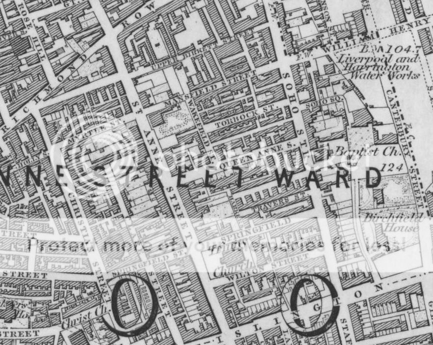
There were two Myrtle Streets. A Myrtle Street or Myrtle Street North and a Myrtle Street South. Myrtle Street North ran between Christian Street and St Anne Street. To the west of the street was Holly Street, to the east of the street was Mansfield Street. On later maps the part of the road that was Myrtle Street North has been renamed Holly Street.
Blue
Re: 1851 census - St Anne Street puzzle
Posted: 18 Jan 2015 18:55
by Blue70
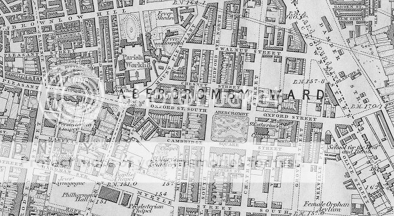
Here's the other one, same year. Note that it says Myrtle Street South.
Blue
Re: 1851 census - St Anne Street puzzle
Posted: 18 Jan 2015 19:57
by MaryA
Solved with Blue's good maps.
Re: 1851 census - St Anne Street puzzle
Posted: 18 Jan 2015 21:56
by daggers
Nice one - again! Thanks for solving it.
D

